File:Apollo 17 Blue Marble original orientation (AS17-148-22727).jpg

From RationalWiki
Jump to navigation Jump to search

Original file(2,400 × 2,400 pixels, file size: 5.97 MB, MIME type: image/jpeg)

This file is from Wikimedia Commons and may be used by other projects. The description on its file description page there is shown below.

Summary

 
Taken with a Hasselblad 500EL camera and 80mm Zeiss lens at stop setting f/2.8 on 70mm Ektachrome film of type SO-368
Description
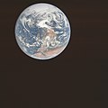
English: NASA original caption: View of the Earth as seen by the Apollo 17 crew on December 7, 1972, traveling toward the moon. This translunar coast photograph extends from the Mediterranean Sea area to the Antarctica south polar ice cap. This is the first time the Apollo trajectory made it possible to photograph the south polar ice cap. Note the heavy cloud cover in the Southern Hemisphere. Almost the entire coastline of Africa is clearly visible. The Arabian Peninsula can be seen at the northeastern edge of Africa. The large island off the east coast of Africa is the Republic of Madagascar. The Asian mainland is on the horizon toward the northeast.
Altitude: Roughly 29,400 km (18,300 miles)
Image center rough coordinates: 17°10'50"N 21°45'19"E
Earth disk center rough coordinates: 26°19’49”S 37°25’13”E
Date UTC
Source http://www.lpi.usra.edu/resources/apollo/frame/?AS17-148-22727 (image link)
Author NASA
Other versions
North-up orientation
Object location26° 19′ 49″ S, 37° 25′ 13″ E Kartographer map based on OpenStreetMap.View this and other nearby images on: OpenStreetMapinfo
This image or video was catalogued by Johnson Space Center of the United States National Aeronautics and Space Administration (NASA) under Photo ID: AS17-148-22727.

This tag does not indicate the copyright status of the attached work. A normal copyright tag is still required. See Commons:Licensing.
Other languages:

Licensing

Public domain This file is in the public domain in the United States because it was solely created by NASA. NASA copyright policy states that "NASA material is not protected by copyright unless noted". (See Template:PD-USGov, NASA copyright policy page or JPL Image Use Policy.)
Warnings:

Captions

The origin photo of the famous ‘Blue Marble’ image, depicting Earth (with the continents of Antarctica on top and Africa plus the Arabian Peninsula near the bottom) from roughly 29,400 km away, on 7 December 1972 at 10:39 UTC

7 December 1972

image/jpeg

201af1b4f3be8e2129bc3ba7ff8ebb0c8f041c8c

6,257,204 byte

2,400 pixel

2,400 pixel

26°19'49.001"S, 37°25'13.001"E

File history

Click on a date/time to view the file as it appeared at that time.

Date/TimeThumbnailDimensionsUserComment
current08:40, 30 October 2021Thumbnail for version as of 08:40, 30 October 20212,400 × 2,400 (5.97 MB)HuntsterReverted to version as of 08:21, 6 June 2015 (UTC); the differences are enough that this needs ot be uploaded to a new filename, but no source was given for this new version. Where did this significantly higher resolution come from...just a cleaned up version of File:EarthOverAfrica.jpg?

The following page uses this file:

Metadata